
Don’t even bother to read this if you’re at work, if you’re getting ready for bed, or if you have a significant other waiting for you to join them. In fact, don’t bother reading this unless you have a solid 3 hours to remain here with your arse glued to the seat.
Google Earth is the coolest thing since Flickr.
In the first hour of using it I was able to find and view (in decent detail) the following:
My birthplace, my parent’s home that burned down on Christmas Eve in ’99, my current abode in the urban jungle of Jakarta, all of the apartments I lived in while at university (still a bit fuzzy), the Cape Town place my mom used to live in, the phenomenal volcanic lake in Bali that I visited last month, the durian-shaped Esplanade in Singapore (photos of which were posted a few days ago), mountains I’ve climbed in New Mexico, my ex-girlfriends’ homes (ok, that was semi-stalker behaviour I admit), plus the usual: Eiffel Tower, Grand Canyon, London Bridge, etc.
I follow the news, read nerd-esque sites (wired, slashdot, etc), regularly browse blogs, and overall am active in the happenings of the web – but it’s been a long time since anything has grabbed my attention like Google Earth. I’ve always been a fan of checking out maps, browsing through atlases, picking up books on a variety of destinations (yes, I own “Earth From Above”) – and this has completely renewed my avid addiction to travel.
It’s fairly straightforward, so I won’t go into detail about using it – check it out for yourself. A few questions come to mind, however:
Could this aid terrorism in any way? (check out Baghdad)
Are there plans to construct a 45-degree viewing angle so as to show more perspective when zooming into cities?
Are there plans to create “fly throughs” for most major attractions?
How old are the images?
Could this ever be a “real time” viewing experience? (probably not, as it would require unthinkable amounts of data and equipment)
How could this be integrated into a variety of professions – city planning, education, real estate, travel agencies, economists, and environmentalists? (check out the rainforest depletion in the Amazon)
Are the advanced features worth the payment?
Why doesn’t it work with Mac yet? (I use a 20″ iMac G5 at home, but a PC at work – can only view it at work)
Could users be more involved without creating a junk-pile of false information? (check out Tokyo with the user-submitted option checked)
How will the similar upcoming Microsoft product compare?
I’ve already considered posting aerial views of the areas I’ve photographed from the ground – that may prove interesting, (but possibly only to me). I’d also like to figure out a way to capture it with video so as to give a better perspective of locations – anyone know a good way to do this? (there’s an optional payment for exporting .wmv)
It’s an exciting time we live in, and yet as the mysteries of the world are now only a click away, it somehow creates feelings of elation as well as a sense of loss – of that wonder that can only be felt from visiting a new destination for the first time with virgin eyes.
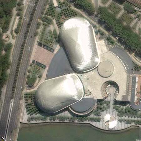
Singapore’s Esplanade – see image from a few days ago below.
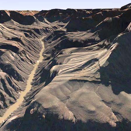
Grand Canyon
St. Peter’s Basillica

Sydney Opera House
